


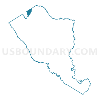
Berea Voting District, Colleton County, South Carolina
About
Outline

Summary
| Unique Area Identifier | 665528 |
| Name | Berea Voting District |
| County | Colleton County |
| State | South Carolina |
| Area (square miles) | 6.76 |
| Land Area (square miles) | 6.73 |
| Water Area (square miles) | 0.03 |
| % of Land Area | 99.62 |
| % of Water Area | 0.38 |
| Latitude of the Internal Point | 33.11803950 |
| Longtitude of the Internal Point | -80.86253730 |
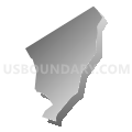
Maps


Graphs
Select a template below for downloading or customizing gragh for Berea Voting District, Colleton County, South Carolina


Neighbors
Neighoring Voting District (by Name) Neighboring Voting District on the Map
- Edisto Voting District, Bamberg County, SC
- Little Swamp Voting District, Bamberg County, SC
- Smoaks Voting District, Colleton County, SC
- Williams Voting District, Colleton County, SC
Top 10 Neighboring County Subdivision (by Population) Neighboring County Subdivision on the Map
- Bamberg CCD, Bamberg County, SC (7,126)
- Smoaks CCD, Colleton County, SC (1,840)
- Ehrhardt CCD, Bamberg County, SC (1,554)
Top 10 Neighboring Unified School District (by Population) Neighboring Unified School District on the Map
Top 10 Neighboring State Legislative District Lower Chamber (by Population) Neighboring State Legislative District Lower Chamber on the Map
Top 10 Neighboring State Legislative District Upper Chamber (by Population) Neighboring State Legislative District Upper Chamber on the Map
Top 10 Neighboring 111th Congressional District (by Population) Neighboring 111th Congressional District on the Map
Top 10 Neighboring Census Tract (by Population) Neighboring Census Tract on the Map
- Census Tract 9602, Bamberg County, SC (7,126)
- Census Tract 9701, Colleton County, SC (1,840)
- Census Tract 9604, Bamberg County, SC (1,554)